The long way home: Navigating broken shrouds and fickle trades on the road to Polynesia
Sailing from Chile to Polynesia’s legendary shores was an adventure across the less travelled routes of the Pacific for Lauric Thiault

The Río Valdivia was glassy when we slipped our lines, the Chilean shores still wrapped in morning mist. For a moment it felt as though our crossing might actually begin gently. Within hours that illusion was gone. The calm gave way to a steep, confused sea, gear crashing below as Tupaia worked her way into water riled by a low-pressure system spun off the Roaring Forties.
Bound for French Polynesia, the South Pacific unfolded ahead of us, our chart dotted with names that read like a sailor’s mythos: Robinson Crusoe, Rapa Nui, Pitcairn. These weren’t just waypoints, they were landmarks of legend.
My partner, Nao, and I had prepared the boat, studied the pilot charts, and waited for what passed as a weather window, but once out there planning only takes you so far. Landfall isn’t earned by determination alone; it’s granted by the whims of wind and sea. That first night, leaving the river calm behind and entering the cold and unsettled seas of the south Chilean coast, we lay in our berths, slightly seasick, and let go of expectation.
Two weeks out and the fresh produce long gone, settling for noodles in the cockpit. Photos: Lauric Thiault
Myth meets reality
Our four-day passage from Valdivia to Robinson Crusoe was rough due to the Humboldt-influenced seas off the Chilean coast, but we made good progress and knew from early on that landfall was assured. What remained unclear was whether we’d be allowed to stay.
The island is not an official port of entry and visiting yachts are permitted more by exception than by right, under procedures that offer little certainty until arrival. We’d braced for bureaucracy or outright refusal. Instead, officers from the Chilean naval authorities met us shortly after we settled at the anchorage and quickly put us at ease. A nod, a smile, and just like that, we were ashore.
Officially renamed in 1966 after Defoe’s fictional character, the island’s real history is tied to Alexander Selkirk, who spent four years marooned here in the early 18th century. His story, and the one it inspired, tend to frame the island as a place of survival rather than beauty. Yet for us, stepping ashore from the main anchorage on the north shore, it felt like a hidden garden of flowers and exotic trees.
We wandered through the island’s only village, surrounded by steep green ridges. After nearly two years in Patagonia’s stark beauty, the change was striking. The air felt warmer, the light brighter, and the colours richer.
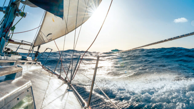
Tupaia at full speed westbound between San Ambrosio and Rapa Nui. Photos: Lauric Thiault
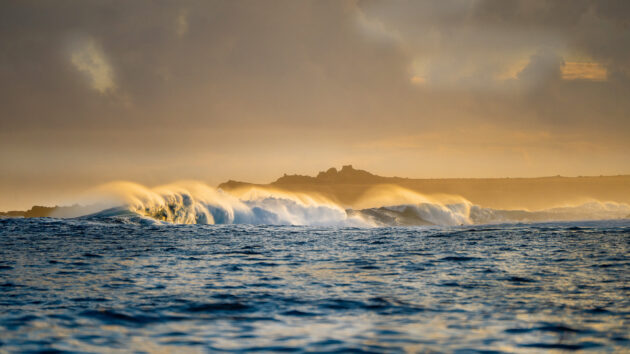
The south, by contrast, was raw and exposed, pounded by an endless southerly swell. There are no true anchorages here, only precarious refuges used when conditions on the north deteriorate, as they did for us. During our time there, sleep was a luxury as Tupaia tugged and rolled at her anchor, but the wild energy of the coast only made the island feel more alive.
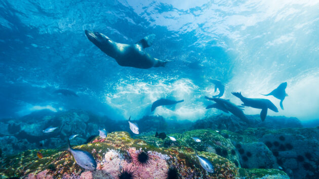
Everywhere we went, we encountered species found nowhere else on the planet, including endemic fur seals, the Juan Fernández firecrown hummingbirds, and two petrel species that breed only here. The archipelago’s biodiversity often draws comparisons to the Galápagos, yet the concentration of endemic marine species is even higher – 98% of fish around Robinson Crusoe are unique to the area. For two marine biologists like us, it seemed like Christmas!
This richness is no accident. The island’s isolation and the community’s commitment to conservation have preserved its natural wealth. In 1935, much of the land became a national park, and in 2018, Chile designated the surrounding waters as one of the world’s largest marine protected areas.
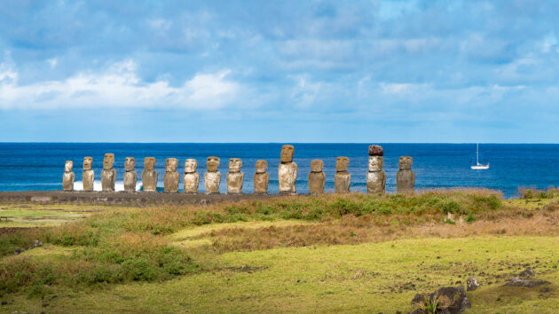
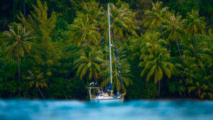
Anchored beneath the iconic moai of Rapa Nui. Photos: Lauric Thiault
Even lobster fishing, the community’s lifeline, is tightly controlled and subject to a four-month annual closure along with strict protections for egg-bearing females. The result is a place where nature and people thrive, and where the rest of us can learn from both.
We found Selkirk’s plaque along a winding island track. His story – four years of solitude – bears little resemblance to our week-long visit. From that spot, looking out at the Pacific, the sense of isolation was real, yet very different: we could leave at any time, and the land, while commanding respect, revealed a welcoming character alongside its harshness. We’d have stayed longer, but the northerlies had other plans, shoving us back into the blue.
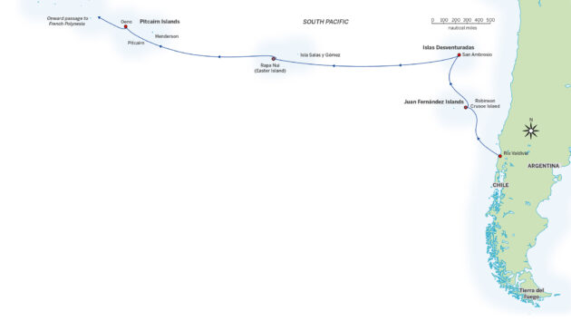
The route taken
Unfortunate islands
San Ambrosio wasn’t supposed to be part of the plan. Until three days out from Robinson Crusoe, we didn’t even know it existed.
Beating windward in mid‑September, we found ourselves in a season of uncertain weather, with winter’s last storms sending remnants our way. Our track zigzagged north, sometimes north-east, as we chased the stubborn tradewinds clinging well above the 20th parallel. Then, a massive high-pressure system settled across our path, threatening to stall us entirely. Zooming in on the chart, I spotted a tiny dot just within reach before the wind died entirely. Better to aim for land, we decided, than to drift aimlessly at sea.
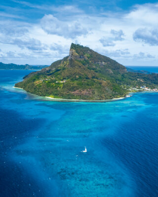
Located 740 miles from mainland Chile, far from shipping lanes and the beaten sailing routes, San Ambrosio is a place few ever see. Its only visitors are lobster fishermen from Robinson Crusoe, who set up temporary camps during the fishing season. With the season over, we had the island to ourselves.

The wild south side of Robinson Crusoe Island is well worth a detour, even if it offers little protection from the swell. Photos: Lauric Thiault
A slab of barren rock – just 3.5km long and 1km wide, all high vertical cliffs and no fresh water – San Ambrosio has no proper anchorage to speak of. Alongside its neighbour, San Felix, it forms the Islas Desventuradas, the Unfortunate Islands, named by early explorers who saw only danger where we saw wonder. To them, these were places to avoid. To us, with the safety benefits of modern navigation, the comfort of Tupaia, and no pressing schedule, they were a gift.
We tucked into a narrow notch on the lee side, just enough to drop the hook. The calm held, allowing us three sunny days of absolute solitude in a world bursting with life.
We never even tried to land. The cliffs made it impossible, but we didn’t need to. From Tupaia’s cockpit we watched as thousands of petrels, gannets, and terns wheeled over our rigging day and night in a mesmerising ballet, their cries rising in a wonderful cacophony. Below the surface, crystal waters swirled with trevallies and yellowtail kingfish. Twice we slipped overboard to swim with fur seals, darting and tumbling through surf and kelp like a pack of playful puppies.
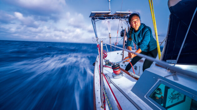
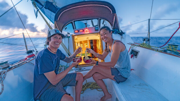
Nao takes the first watch as the night settles in. Photos: Lauric Thiault
Transition zone
From San Ambrosio, we followed the Nazca Ridge toward Rapa Nui, or Easter Island, a 1,600-mile stretch with no landfall options and only the pilot charts’ promise of gentle conditions. Instead, this leg became the most mentally gruelling of the crossing.
We were still in the transition zone, where the forecast consistently showed strong frontal systems arriving from the south-west every couple of weeks, bringing wind shifts of up to 180°. Between fronts, winds were weak and met an unusually agitated sea, creating conditions far less pleasant than we’d anticipated.
There were brief, perfect moments under the gennaker, but they were outnumbered by days of uncomfortable rolling in short, confused swells. The wind hovered in that maddening sweet spot, providing just enough to keep the sails up, but just little enough to make you wish they were down. Calms reduced our track to a series of hesitant zigzags, punctuated now and then by brief blasts of wind that teased progress but refused to last, a frustrating tension where patience mattered more than seamanship.
Article continues below…
We never turned on the engine. Our philosophy is simple: reserve it for emergencies or final approaches. Even as the sails flapped uselessly, we stuck to it. At our lowest point, we considered bailing on Rapa Nui entirely. The Galápagos, closer and with reliable winds, called to us. So did the Marquesas. The temptation of trading this awkward limbo for predictable sailing with a clear destination was hard to dismiss.
Then, during a routine deck check, I discovered that three shrouds had become damaged overnight – likely due to a mix of constant sail flogging and an adjustment I’d botched before departure. No use dwelling on it. We rigged temporary running backstays from spare Dyneema, secured everything we could, and got back to what mattered: embracing the voyage, flaws and all.
Once we accepted the drifting and rolling as part of the passage, a strange peace settled in. With the sails down to protect the rig and limit wear, there was no longer any rush to chase the next fragile bubble of wind on the chart, no need to force progress where none was to be had.
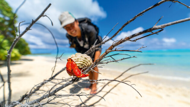
Meeting the locals in Oeno. Photos: Lauric Thiault
Our world shrank to the boat. The same simple routine filled the days – cooking, sleeping, reading, and the occasional swim in the vast Pacific to remind ourselves just how small we were.
After three days that felt like 10, the breeze finally filled in. The boat came alive, creaking, groaning, and holding together again as we pushed along at six knots through moderate breaking seas. A satisfying pace for an overloaded, over-reefed 35-footer, and a welcome release from the stagnation of the transition zone.
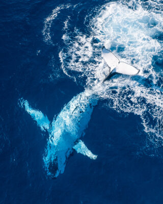
humpback whale off Oeno. Photos: Lauric Thiault
Mysterious icons
The Pacific was once a wall between worlds, separating the Americas from Polynesia and the scattered island societies to the west. Polynesian navigators transformed it into a highway, crossing immense distances guided by stars, swells, and the flight of birds. Their voyages enabled exchanges – sweet potatoes, chickens, even DNA – that still puzzle researchers today. With digital charts and GRIBs, finding Rapa Nui now is technically simple, yet it doesn’t diminish its significance. After weeks of open ocean, reaching it makes you grasp the scale of what the ancient voyagers achieved.
Often described as one of the most remote inhabited islands on Earth, Rapa Nui is surprisingly well connected today, with daily flights to mainland Chile and several monthly supply ships. In Hanga Roa, the island’s only town, we shared the anchorage with two of them, watching cars and containers unload in the rolly, exposed bay with a mix of amusement and disbelief.
The shore break makes landing at Rapa Nui a daunting task. Photos: Lauric Thiault
Every few days we shifted anchorages as the wind swung yet again. Yet no matter where we went, the swell found us. The inter-season didn’t help. Summer’s steady trades were still weeks away, leaving us at the mercy of passing southern storms. But when your morning view is the Pacific’s most iconic silhouettes, discomfort fades fast.
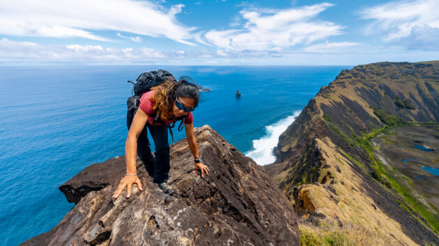
Landing with a small, lightly powered dinghy is tricky in calm conditions, reckless in anything over 3m of swell. Once ashore, we tied up in the tiny fishing harbour and explored on foot. We moved through a rugged and windswept landscape, surrounded by extinct volcanoes, rolling hills, and dark lava rock, while steep volcanic cliffs and deep pocket beaches meet the deep blue Pacific in stark contrast.
We’d imagined encountering the famous moai statues only at the main tourist sites. In reality, they are everywhere, lined along roads, dotting the coastline, and perched atop hills. Their presence is inescapable, a constant reminder of the island’s ancient past.
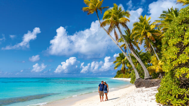
Exploring a tropical paradise. Photos: Lauric Thiault
Standing before them, their sheer improbability hits you. Generations spent centuries carving, moving, and raising these figures, driven by a purpose we’ll never fully understand. The how is debated, the why may be lost forever. But it’s clear that moai are not merely symbols. They are the result of extraordinary organisation, shared belief, and relentless effort in a place where every resource was scarce.
Today, rising seas and erosion threaten this legacy. Yet a new generation of Rapa Nui is fighting to preserve it. Conservationists restore ahu (ceremonial platforms), guides weave ancestral stories into modern tours, scientists track erosion and biodiversity, artists keep traditions alive through carving, music, and dance. Halfway through our voyage, Rapa Nui felt like the perfect bridge, a place where ancient mysteries and living culture meet.
Juan Fernández fur seals at play in the swell. Photos: Lauric Thiault
A wild Pacific atoll
Standing night watches beneath an impossibly dark sky, the Milky Way spilling from horizon to horizon, is one of the many privileges of ocean passages. Our course was next set for the Gambier Islands, a distant archipelago in south-eastern French Polynesia. But to catch the tradewinds, we had to detour north again. Each night, the boat moved through a seascape of constellations punctuated by the occasional streak of a shooting star. With the air warming we’d lie in the cockpit for hours, simply letting the vastness sink in.
After five days of northbound sailing in doldrums-style conditions, the trades finally filled in. Steady, warm, and generous for once, they carried us westward. But the Pacific’s moods are fickle, and by the time we reached Pitcairn’s longitude, the wind vanished again.
‘After nearly two years in Patagonia’s stark beauty
the change was striking. The air felt warmer, the
light brighter and the colours richer’. Photos: Lauric Thiault
We’d been tempted by Pitcairn itself, drawn by the chance to meet the descendants of the Bounty mutineers and walk the same paths as Fletcher Christian. But for us, the real treasure lay 60 miles north-west: Oeno, a small atoll part of the UK’s Pitcairn Islands overseas territory, whose name we’d never even heard before. That mystery alone was enough to pull us off the obvious choice.
Oeno announced itself subtly, its turquoise waters colouring the clouds before the land itself came into view. As we closed the distance, seabirds gathered around us in growing number, and a group of seven humpback whales surfaced nearby, lingering as if in no hurry to continue their migration back toward Antarctica.
Little more than a ring of coral and sand, its lagoon is sealed by an unbroken reef. With no pass to enter and the swell still too high, we hove-to for the night, waiting for conditions to ease. The following day, we anchored in a sandy patch on the outer reef to the north. Each afternoon, the whales returned, breaching and exhaling just metres from the boat.
One final walk along Rapa Nui’s volcanic ridge, taking in the views before heading back to sea. Photos: Lauric Thiault
Ashore, it felt like a postcard come to life, with white sand beaches, driftwood sculpted by the tide, and thousands of terns, noddies, petrels, and frigates wheeling overhead or nesting in the scrub. Three decades ago, conservationists eradicated the rats that once ravaged the island. Now, it’s a rodent-free sanctuary, home with neighbouring Ducie to 95% of the world’s Murphy’s petrels and half a million other breeding pairs. Oeno anchors the Pitcairn Islands marine protected area, one of the planet’s largest no-take zones. The reef explodes with life, schools of surgeonfish the size of car tyres, parrotfish crunching coral, turtles gliding past. Just beyond the breakers, tuna boil the surface, hunting all day long.
Yet even here, the wider world intrudes. Plastic debris – bottles and FADs (fish aggregating devices) for the most part – washes up on the shore, carried by the South Pacific Gyre. But the atoll’s vitality drowns out these distant intrusions. It feels like a time capsule, a glimpse of the tropical Pacific as it was centuries ago.

Turquoise seas inside the reef of the tiny Oeno atoll, part of the Pitcairn Islands overseas territory. Photos: Lauric Thiault
Homecoming waters
We stayed four nights and left only when the wind returned. Just two days later we arrived in the Gambier Islands. The approach felt unlike any landfall before it. After two months and 4,860 miles (about 1,400 more than the theoretical route) of fickle winds and ocean swell seeping into every corner of our lives, the lagoon’s embrace was pure relief. The water flattened, the motion eased. For the first time in a long while, our boat lay still. Calm at last.
For Tupaia, this was uncharted territory. She’d never been to French Polynesia before, despite bearing the name of the great Polynesian navigator who once guided Cook across these same waters. There was something very satisfying about finally bringing her here, as if name and place had finally aligned.
For me, it was a homecoming. I grew up in French Polynesia and spent years here as a marine biologist.
The water, the light, the slow pulse of island life were just as I remembered from 10 years ago. French Polynesia, I was glad to see, was still French Polynesia.
 If you enjoyed this….

Yachting World is the world’s leading magazine for bluewater cruisers and offshore sailors. Every month we have inspirational adventures and practical features to help you realise your sailing dreams.Build your knowledge with a subscription delivered to your door. See our latest offers and save at least 30% off the cover price.
Note: We may earn a commission when you buy through links on our site, at no extra cost to you. This doesn’t affect our editorial independence.
The post The long way home: Navigating broken shrouds and fickle trades on the road to Polynesia appeared first on Yachting World.